
28 Parsing QGIS Style Files to GemGIS
Contents
28 Parsing QGIS Style Files to GemGIS#
The following will present how to load QGIS style files (QML files) into GemGIS, how to set the colors for GeoPandas plots and how to automatically set the surface colors for a GemPy model.
QML is an XML format for storing layer styling. A QML file contains all the information QGIS can handle for the rendering of feature geometries including symbol definitions, sizes and rotations, labelling, opacity and blend mode and more.
Set File Paths and download Tutorial Data#
If you downloaded the latest GemGIS version from the Github repository, append the path so that the package can be imported successfully. Otherwise, it is recommended to install GemGIS via pip install gemgis and import GemGIS using import gemgis as gg. In addition, the file path to the folder where the data is being stored is set. The tutorial data is downloaded using Pooch (https://www.fatiando.org/pooch/latest/index.html) and stored in the specified folder. Use
pip install pooch if Pooch is not installed on your system yet.
[1]:
import gemgis as gg
file_path ='data/28_parsing_QGIS_style_files/'
WARNING (theano.configdefaults): g++ not available, if using conda: `conda install m2w64-toolchain`
C:\Users\ale93371\Anaconda3\envs\test_gempy\lib\site-packages\theano\configdefaults.py:560: UserWarning: DeprecationWarning: there is no c++ compiler.This is deprecated and with Theano 0.11 a c++ compiler will be mandatory
  warnings.warn("DeprecationWarning: there is no c++ compiler."
WARNING (theano.configdefaults): g++ not detected ! Theano will be unable to execute optimized C-implementations (for both CPU and GPU) and will default to Python implementations. Performance will be severely degraded. To remove this warning, set Theano flags cxx to an empty string.
WARNING (theano.tensor.blas): Using NumPy C-API based implementation for BLAS functions.
[2]:
gg.download_gemgis_data.download_tutorial_data(filename="28_parsing_QGIS_style_files.zip", dirpath=file_path)
Downloading file '28_parsing_QGIS_style_files.zip' from 'https://rwth-aachen.sciebo.de/s/AfXRsZywYDbUF34/download?path=%2F28_parsing_QGIS_style_files.zip' to 'C:\Users\ale93371\Documents\gemgis\docs\getting_started\tutorial\data\28_parsing_QGIS_style_files'.
Load Files#
A shape file containing Polygons is loaded for demonstration.
[2]:
import gemgis as gg
import geopandas as gpd

polygons = gpd.read_file(file_path + 'interfaces_polygons.shp')
polygons
WARNING (theano.configdefaults): g++ not available, if using conda: `conda install m2w64-toolchain`
C:\Users\ale93371\Anaconda3\envs\test_gempy\lib\site-packages\theano\configdefaults.py:560: UserWarning: DeprecationWarning: there is no c++ compiler.This is deprecated and with Theano 0.11 a c++ compiler will be mandatory
  warnings.warn("DeprecationWarning: there is no c++ compiler."
WARNING (theano.configdefaults): g++ not detected ! Theano will be unable to execute optimized C-implementations (for both CPU and GPU) and will default to Python implementations. Performance will be severely degraded. To remove this warning, set Theano flags cxx to an empty string.
WARNING (theano.tensor.blas): Using NumPy C-API based implementation for BLAS functions.
[2]:
| id | formation | geometry | |
|---|---|---|---|
| 0 | None | Sand1 | POLYGON ((0.256 264.862, 10.593 276.734, 17.13... |
| 1 | None | Ton | POLYGON ((0.256 264.862, 0.188 495.787, 8.841 ... |
| 2 | None | Sand2 | POLYGON ((0.188 495.787, 0.249 1068.760, 278.5... |
| 3 | None | Sand2 | POLYGON ((511.675 1068.852, 971.698 1068.800, ... |
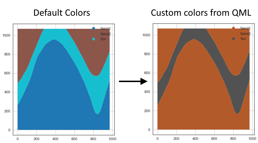
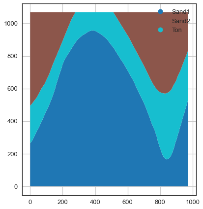
Plotting the data with default colors#
[3]:
import matplotlib.pyplot as plt

polygons.plot(column='formation', aspect='equal', legend=True)
plt.grid()
Loading the QML File#
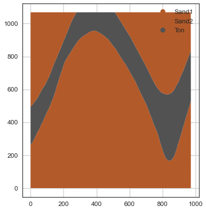
Loading a QML style file. The GeoDataFrame of the plotted polygons have to be provided to create a list of colors. These colors are equal to the unique() formations the geological map contains. The surface colors can be loaded with load_surface_colors(..) by providing the path to the style file and the corresponding GeoDataFrame.
[4]:
cols = gg.utils.load_surface_colors(path=file_path + 'style.qml',
                                    gdf=polygons)
cols
[4]:
['#b35a2a', '#b35a2a', '#525252']
[5]:
polygons['formation'].unique()
[5]:
array(['Sand1', 'Ton', 'Sand2'], dtype=object)
Plotting the data with loaded colors#
The Polygons can now be plotted using matplotlib ListedColormap feature.
[6]:
import matplotlib.pyplot as plt
from matplotlib.colors import ListedColormap

polygons.plot(column='formation', aspect='equal', legend=True, cmap=ListedColormap(cols))
plt.grid()
Creating surface color dictionary from Style File#
A surface color dict can be created to change the colors of a GemPy Model by using create_surface_color_dict(..).
[7]:
surface_color_dict = gg.utils.create_surface_color_dict(path=file_path + 'style.qml')
surface_color_dict
[7]:
{'Sand1': '#b35a2a', 'Sand2': '#b35a2a', 'Ton': '#525252'}