
Tutorials and Basic Usage
Tutorials and Basic Usage#
There is a series of tutorials available for GemGIS. In order to keep the size of the main GemGIS package as small as possible, the data is provided through a separated repository gemgis-data. You can also download the data directly following this link.
Watch our Video Tutorials: link to be provided soon
The following subsections elaborate on the basic API usage of GemGIS. This includes the extraction of information from input data files, the creation of new data and the preparation of data for the geomodeling with GemPy. The respective reading or loading functions of packages such as GeoPandas or rasterio will be used to load the data as GeoDataFrame or rasterio object.
The aim of this and the upcoming tutorials is to demonstrate how to prepare spatial data for geomodeling with GemPy to get a geological model. Raw data is usually created/digitized within QGIS which we encourage the user to use!
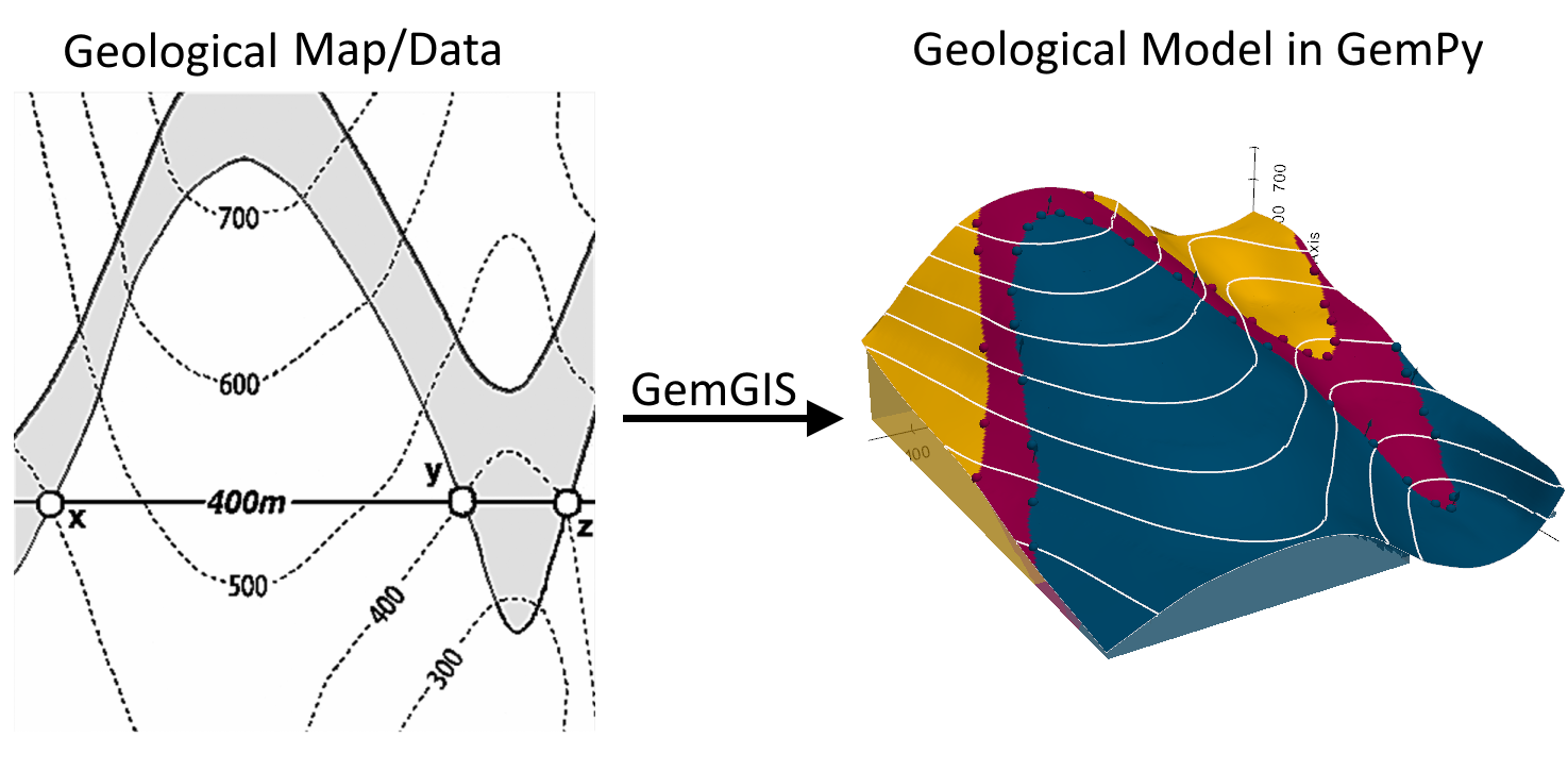
Source: Powell, D. (1995): Interpretation geologischer Strukturen durch Karten - Eine praktische Anleitung mit Aufgaben und Lösungen, page 15, figure 10 A, Springer Verlag Berlin, Heidelberg, New York, ISBN: 978-3-540-58607-4.
Each set of functions of GemGIS is collected in a different module. The functions of each module can be accessed as followed:
import gemgis as gg

data = gg.vector.function_name(...)

data = gg.raster.function_name(...)

data = gg.visualization.function_name(...)

data = gg.web.function_name(...)

data = gg.utils.function_name(...)

data = gg.misc.functions_name(...)
Tutorials
- 00 Generating Data in QGIS for GemGIS
- 01 Extract XY Coordinates
- 02 Extract XYZ Coordinates
- 03 Exploding Geometries
- 04 Clipping Vector and Raster Data
- 05 Interpolating Rasters
- 06 Sampling from Rasters
- 07 Calculating Raster Properties
- 08 Sampling Interfaces and Orientations from Raster
- 09 Raster Operations in GemGIS
- 10 Visualizing Spatial Data with PyVista
- 11 Removing Interface Points within Fault Buffers
- 12 Visualizing Geological Cross Sections with PyVista
- 13 Extracting Interface Points and Orientations from Geological Cross Sections
- 14 Visualizing Topography and Maps with PyVista
- 15 Opening Leapfrog Meshes and GoCAD TSurfaces with GemGIS
- 16 Extracting Interfaces from Geological Maps
- 17 Plotting Orientations with mplstereonet
- 18 Creating Depth Maps from GemPy Models
- 19 Working with Web Map Services - WMS
- 20 Working with Web Feature Services
- 21 Working with Web Coverage Services
- 22 Creating Temperature Maps from GemPy Models
- 23 Calculating Thickness Maps with PyVista
- 24 Plotting Hypocenters of Earthquakes with PyVista
- 25 Creating Orientations from Isolines on Maps
- 26 Working with Well Data from the Geological Survey NRW
- 27 Opening OBJ and DXF Files with PyVista in GemGIS
- 28 Parsing QGIS Style Files to GemGIS
- 29 Calculating Orientations from Strike Lines
- 30 Opening GeoDataBases for GemGIS
- 31 Obtaining City Locations
- 32 Using ipyvtk with PyVista for Visualization
- 33 Slicing Geological Models with PyVista
- 34 Interpolating Strike Lines with GemGIS
- 35 Plotting Borehole Data with PyVista
- 36 Creating proj.crs.crs.CRS Objects for GemGIS
- 37 Delaunay Triangulation for Isoline Maps
- 38 Interactive plotting with Bokeh in GemGIS
- 39 Working with Shapely Base Geometries containing Z components
- 40 Working with GPX Data in GemGIS
- 41 Working with KML data
- 42 Draping LineStrings over Digital Elevation Model in PyVista
- 43 Creating LineStrings from PyVista Contour Lines
- 44 Fitting a plane through earthquake hypocenters
- 45 Opening ESRI ASC Grids and ZMAP Grids
- 46 Working with HGT Files in GemGIS
- 47 Delaunay Triangulation of Shapely Multipoints
- 48 Georeferencing Rasters using Rasterio in GemGIS
- 49 Slicing GemPy Lith Blocks in PyVista with GemGIS
- 50 Parsing Leapfrog Wells
- 51 Assigning physical properties to GemPy lith blocks
- 52 Digitizing data from PyVista Meshes
- 53 Adding anthropogenic geometries to PyVista
- 54 Converting PyVista Mesh to ZMAP Grid
- 55 Extracting Well Tops from PyVista Meshes
- 56 Displaying Seismic Data in PyVista
- 57 Creating Spaghetti plots in GemPy
- 58 Creating hexagonal grid in GemGIS
- 59 Visualizing DoubletCalc Results
- Reading DoubletCalc Results CSV File
- 60 Adding labels to PyVista Contour Lines
- 61 Exporting Geological Maps and Custom sections from GemPy
- 62 Extracting contour lines from raster
- 63 Displaying Well Log along Well Path
- 64 Creating Seismic Line Density Maps
- 65 Displaying Seismic Horizons and Faults
- 66 Generating Voronoi Polygons
- 67 Rotating GemPy Input Data
- 68 Creating Finite Faults with GemGIS
- 69 Export GemPy model into blender
- 70 Reprojecting Seismic Data and extracting path and CDP points from Seismic Data
- 71 Opening Rasters from OpenFileGDB